| Tutor(s) | Gisèle Gantois |
| Campus | Ghent |
| Language | EN |
| Engagement | Craftsmanship |
| Semester | SEM 1 |
Site
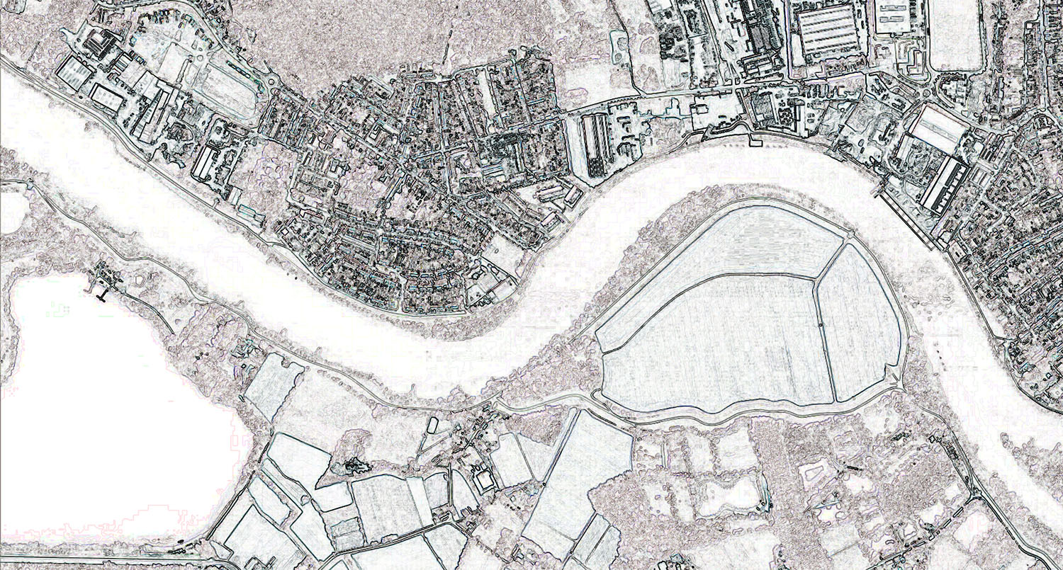
Terhagen (Meso-scale) is part of the municipality of Rumst, which is situated on the north bank of the tidal river Rupel together with the municipalities of Hemiksem, Schelle, Niel and Boom. These five municipalities have in common their geomorphological structure with the cuesta and their historical evolution with (former) clay exploitation. The river basin of the 12 km long tidal river Rupel is part of the Flanders-Dutch Scheldt delta. This is unique in its kind, because of the special interaction between natural processes and cultural history.
Less commonly known is that the Rupel region had next to the brick industry other important activities in many other branches of industry such as steal industry, with numerous shipyards; the food industry, with various gin distilleries and beer breweries; the diamond industry; the shoe and slipper industry and the glass industry.
This intensive industrial past is expressed in the alienating cultural landscape of the Rupel region (Macro-scale), which is marked by over 400 years of clay mining and the production of bricks, pipes and roof tiles, with numerous clay pits (refilled or not) and industrial heritage relics scattered all over the landscape. A number of valuable sites have remained. The special waffle structure of the landscape with pits and ridges, the pecular housing typologies on the flanks of the pits all interconnected by a fragile mesh of easements over private land which guaranteed fluent trespassing, played and still play an important role in the identity, quality and (social) cohesion of the region.
Today, new migration and mobility, but also nature (nature has reclaimed space and created new habitats that are exceptional for their biodiversity value) give rise to new meanings for the Rupel region. As a peri-urban2 region, however, there is also increasing pressure as a housing expansion area for Antwerp. To date, a overall vision is lacking, which means that each municipality individually outlines its own policy or takes decisions plot by plot. More over, the region not only underwent a drastic change after the collapsing of the brick industry but in Terhagen, as in other villages and towns of Flanders, the church, rectory and local primary school for girls situated in a local convent were closed because of the dwindling of Catholic Religion and the reduce of public funding for the maintenance of the buildings. The communal school for boys was also closed. The church is now used as community centre for cultural events (GAM) and the former school for girls, houses a health fund. The village still has very valuable architecture built by the former factory owners during the heyday of the brick industry. These beautiful mansions make the village one of a kind, as most other villages in the region were historically characterized by the alternation of industrial estates and small clusters of working-class housing, resulting in intense pollution and very poor living and working conditions.
The village of Terhagen lies in an armpit of the river and is furthermore surrounded by (former, whether or not filled in) clay pits. Next to the residents of the village, there are other important players in the region such as the Flemish Government and the Province of Antwerp (with the remediation of parts of the contaminated clay pits situated north of Terhagen), Nature Point (with the management of nature areas), an annual large-scale outdoor dance event (with storage and camping), the only remaining brick producer, and recreation seekers (cyclists and walkers).
Goals:
This studio aims to understand the historical and ever changing layers of meaning of a given area situated in a post-industrial landscape on the one hand and to generate new ones on the other by looking at this both on the larger landscape scale of the Scheldt-Rupel river basin area (macro), the scale of the village of Terhagen and on the micro scale while considering the reconversion of one of the abandoned historical buildings in the centre of the village. Further more we will investigate the interdependence of the non-built and built as part of the same cultural landscape. The architectural proposals will be characterized by an active approach to the cultural landscape, in which the heritage relic is no longer treated as an isolated object, but as part of a lively (community) landscape.
With the study of the village of Terhagen we not only ask what heritage is or can be by looking at the conditions of the post-industrial landscape of this village, but we also try to understand what the contemporary significance of the village is for the residents of Terhagen, by combining their authentic experiences expressed in their daily interaction with their living environment with our own experiences on site and we will then confront the gathered knowledge with existing data, including historical archives and maps.
Different research/design questions can be formulated:
- What is the significance of the post-industrial landscape for the inhabitants of Terhagen and how can we detect, reveal and map this in a tactile way? What is the place of the different heritage buildings herein?
- What resilient anticipative design strategies can we define for the heritage of this village more particularly for one of the abandoned historical buildings in the heart of the village, considering un-predefined scenarios?
- In which way can the repurposing of one of these abandoned historical buildings in the context of this village generate additional opportunities for the reinforcement of the existing spatial and social mesh of the village?
- How can this building, and by extension the village of Terhagen, deal with its industrial past, so that the emphasis is no longer on the built construction as passive isolated object, but as a living structure in constant metamorphosis that enables the creation of new memories and associations of local people and newcomers?
- How can we involve the inhabitants of the village more intensively in our new plans?
- How can we explore the notion of “cultural living landscape” in which the tangible, intangible and living elements of this post-industrial landscape are included in order to achieve more (socially) sustainable development in the village?
- What about the river and the pioneering forests?
At the start of the research, each student will critically question and further define these initial research questions and will formulate new or additional questions that result in an individual design proposal. As a triggering idea we will start from the current wish of some of the local stakeholders to install community activities in these vacant buildings. Depending on the students’ own design research this dream scenario will be explored, questioned, widened and/or adapted in close interaction with different local protagonists.
This exercise aims to investigate how ordinary citizens with their real-life experiences interfere in top-down made proposals while enabling the co-creation of a resilient palimpsestic village in contrast with the predominant discourse on development and economic profits. From here those elements will be distilled, supported with intense fieldwork that will be helpful to understand the village’s multilayered appearance today while unraveling and highlighting its spatial fabric. Bridges will be made to actual cases of urban resilience in post-industrial areas. Questions will be formulated about whether and how the historical spatial configuration contributes to the process of recovery after decline of the industry.
What future for this post-industrial landscape?
The basis of this real-life case is intense fieldwork with the Interactive Walking method developed by the author (G.G.). This will result in graphical representations on small and large scale and in tactile models on different scales representing the multi-layered cultural landscape of the village and the chosen site in the village.
Keywords:
Social sustainability, Interactive, Collective Space, Local Identity, Appropriation, Social Meshwork, Community, Community Based Approaches, Storytelling, Palimpsest, Resilient Environments, Cultural Landscape, Recovery, Regeneration
Excursion/study trip/…? (+ timing):
Intense survey on location is an essential part of this exercise!
In the first three weeks (starting from week 2) you will work individually and in small teams to gather information and to get acquainted with the site perimeter and the topic. This should enable you to make a final informed choice for a specific site in week 7.
to be confirmed (depending of the academic calendar):
Week 1: ASSEMBLEA
Week 2: Introduction + lecture Gisèle Gantois + study material + Exploration Terhagen
Week 3: Exploration Terhagen
Week 4: studio in Ghent to discuss first observation and representations, creation of Spatial Narratives
Week 5: Exploration Terhagen, Noeveren en Hellegat
Week 6: studio in Ghent, Questioning the first exploration, creation of Cartes Parlantes
Week 7: studio in Ghent, choice of case
Week 8: studio in Ghent
Week 9: studio in Ghent
Week 10: Presenting first results in Terhagen. Questioning these results after interactive discussions.
Week 11: studio in Ghent
Week 12: studio in Ghent
Week 13: studio in Ghent
Week 14: Evaluation
Evaluation criteria:
See ECTS
Evaluation method:
The students will present their work orally in an exhibition. Jurymembers will be local experts and teachers-(interior-)architects and/or urban designers.
See also ECTS
Learning outcomes:
See ECTS
References/Further reading:
Location-specific information will be provided during the introduction session.
The reader will be built up together with the students according to their fields of interest.
Reference for the image (if necessary):
Methodology – Modus Operandi
Before developing individual approaches, strategies, methods and instruments, the exercise starts with a number of reflections and a proposed research method to enable the students to immerse into the given study area. The detection and implementation of multiple narratives, old and new, graphically recorded through casual and organized encounters, is encouraged.
Interactive Walking
It is inherent to the twofold profile of the architect/student with an interest in heritage to simultaneously look at the present and the future as an architect who helps to shape that future and to look back from the present to the past in order to understand that present. Heritage and cultural landscapes embody successive movements, memories, experiences and dreams. To that extent, this studio meanders through different temporalities, not only in the way it looks at the historical landscape, but also in its design-oriented research method. Although a strict division does injustice to the versatility of the different disciplines, the methodology of Interactive Walking combines methods and tools from different academic traditions, including heritage studies (studying the past), anthropology (observing contemporary humans in their living environment) and architecture (thinking and shaping the future). We investigate how the movement through the landscape, the narratives and life itself are closely intertwined.
The 3-steps methodology of Interactive Walking is a tool to explore the cultural landscape, not only to discover and understand the multiplicity of meanings of the site for its inhabitants, newcomers and visitors, but also to integrate the gathered knowledge in an (architectural) intervention as a generator for Terhagen, and its inhabitants.
The deeper meaning of a place can never be discovered by mere formal research or simply collecting information “from above” (such as in archives or databases). Therefore, students will explore the village, and the wider environment intensively on location.
As a first step (Step 1: Interactive Journeys) and to facilitate the process of getting acquainted with the site, the student will explore the site by walking according to a well-defined protocol. No existing maps are consulted prior to this intense period on site. No photos are taken during the initial explorations. As a first step, the observations and experiences, the spontaneous conversations with residents and visitors are recorded chronologically by drawing and writing in small homemade notebooks. In the evening, the journey of that day is recorded at the back of the unfolded sketch booklet.
As foreign travellers, the students will have to orient themselves by marking reference places. They will be asked to link their discoveries to memories of events in other places. In this way they will draw up their own personal visual and experimental maps of the neighbourhood and the region.
The small booklets will serve as a personal lens for each student through which s/he views and experiences the site and the way s/he interacts with the residents. This will create a specific angle that, as an important player, will help create tension between existing and new data, and to identify spatial and programmatical urgencies that will form the basis of further research and the (architectural) project proposals. These will be driven as much as all the actors involved will question them. In order to make this possible, close cooperation is envisaged with local experts, professional or not.
As a second step (Step 2: Spatial Narratives) the collected experiences and information about the neighbourhood and surroundings are processed, selected and visualized in artistic maps and models from a clearly personal interest, and this through reflection on one’s own individual discoveries, translated into things outlined in the notebooks. This involves mediating between experiences on site and how the architect on the basis of existing maps traditionally represents this. (Think of how a landscape with feet on the ground is really experienced with highs and lows, bends and vistas, church towers as reference points and forests obscure the view and how this landscape is represented from a topographical map, from a bird’s eye view.)
In a third step (Step 3: Cartes Parlantes) students are asked to combine their experiences with existing expert data such as official data, archives, existing topographical, geological and road maps or historical maps. These official maps and data are rearranged as a series of alternative maps reimagining the (urban) landscape. This exposes possible unexpected relationships and interactions between different layers and reveals the deeper meaning of the site as part of a lively process.
In this way one or more design questions arise, which are further defined in the course of the exercise.
The conceptual choices that each student makes in the design will visualize the special stratification of the (urban) landscape and enable its communication to third parties. Special attention will be given to large sections linking the chosen site to the larger context and models on different scales.
This exercise has to be situated within the ADO Restoring Broken Journeys and within the Engagement Craftsmanship (from 2020-2023 Engagement Legacy).
Other assignments within the ADO Restoring Broken Journeys:
# 1. Leaf is Tree and Tree is Leaf, House is City and City is House… Case Hellegat (2020-2021 – SEM 4)
# 2. Church ain’t out ‘til they quit singing. Hinge: Saint-Joseph church Hellegat (2021 – 2022 – SEM 1)
# 3. Vicinity as nearness in Space. Hinge: Former Brick Production site in Noeveren (2021 – 2022 – SEM 4)
# 4. Palimpsestic Landscape – Urban Resilience after disaster (2022 – 2023 – SEM 1)
# 5. Care-Taking as Iterative Process (2022 – 2023 – SEM 4)